Moncrieffe Hill
eMTB Gravel: Tay Car Park -> Moredun Top Hillfort - Loop (Geocaching) #UK #Perthshire #Perth #Bike #Nature #Forest #Countryside
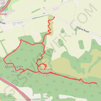
- Distance: 4.8 mi
- Elevation gain: 223 m
- Maximum elevation: 219 m
- Elevation loss: 223 m
- Minimum elevation: 76 m
- Moving time: 55 m 30 s
- Moving speed: 5.2 mph
- Maximum speed: 13.6 mph
- Total time: 1 h 33 m
- Global speed: 3.1 mph
Interactive trail map
Trail profile
- Distance: 4.8 mi
- Elevation gain: 223 m
- Maximum elevation: 219 m
- Elevation loss: 223 m
- Minimum elevation: 76 m
- Moving time: 55 m 30 s
- Moving speed: 5.2 mph
- Maximum speed: 13.6 mph
- Total time: 1 h 33 m
- Global speed: 3.1 mph
About this trail
Name: Moncrieffe Hill trail, distance, elevation, map, profile, GPS track
Start: Rhynd Road, Rhynd, Perth, Perth and Kinross, Scotland, PH2 8QH, United Kingdom (56.37335 -3.39671)
Coordinates: 56.36128 -3.41331 56.37336 -3.38286
Topography: Perth topographic map, elevation, terrain
Other hiking, mountain biking, running and outdoor activity trails
Click on a trail to view its statistics, map and profile.
Walking on Moncrieff Hill near Perth
United Kingdom > Scotland > Perth and Kinross > Bridge of Earn
Distance: 5.0 mi • Elevation gain: 229 m • Maximum elevation: 219 m