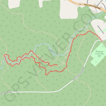
Thames Creek
Loop hike along Thames Creek via Therapy and Picker's Path on Vancouver Island. #Hiking #Loop #River #Nature #Forest
- Distance: 2.8 mi
- Elevation gain: 36 m
- Maximum elevation: 107 m
- Elevation loss: 93 m
- Minimum elevation: 34 m
- Moving time: 1 h 17 m
- Moving speed: 2.2 mph
- Maximum speed: 2.4 mph
- Total time: 1 h 17 m
- Global speed: 2.2 mph
Interactive trail map
Trail profile
- Distance: 2.8 mi
- Elevation gain: 36 m
- Maximum elevation: 107 m
- Elevation loss: 93 m
- Minimum elevation: 34 m
- Moving time: 1 h 17 m
- Moving speed: 2.2 mph
- Maximum speed: 2.4 mph
- Total time: 1 h 17 m
- Global speed: 2.2 mph
About this trail
Name: Thames Creek trail, distance, elevation, map, profile, GPS track
Coordinates: 49.42243 -124.68959 49.42945 -124.66532
Other hiking, mountain biking, running and outdoor activity trails
Click on a trail to view its statistics, map and profile.