Thank you for supporting this site ❤️
Make a donation
Make a donation
Gear up for your next adventure:
As an Amazon Associate, this site earns from qualifying purchases at no extra cost to you.
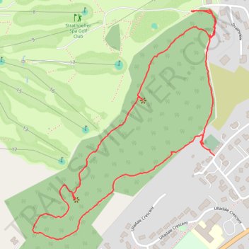
Loop hike in the forest above Strathpeffer
- Distance: 1.5 mi
- Elevation gain: 124 m
- Maximum elevation: 178 m
- Elevation loss: 109 m
- Minimum elevation: 92 m
- Moving time: 40 m 30 s
- Moving speed: 2.2 mph
- Maximum speed: 5.9 mph
- Total time: 52 m 48 s
- Global speed: 1.7 mph
Interactive trail map
Thank you for supporting this site ❤️
Make a donation
Make a donation
Gear up for your next adventure:
As an Amazon Associate, this site earns from qualifying purchases at no extra cost to you.
Trail profile
- Distance: 1.5 mi
- Elevation gain: 124 m
- Maximum elevation: 178 m
- Elevation loss: 109 m
- Minimum elevation: 92 m
- Moving time: 40 m 30 s
- Moving speed: 2.2 mph
- Maximum speed: 5.9 mph
- Total time: 52 m 48 s
- Global speed: 1.7 mph
Thank you for supporting this site ❤️
Make a donation
Make a donation
Gear up for your next adventure:
As an Amazon Associate, this site earns from qualifying purchases at no extra cost to you.
About this trail
Name: Loop hike in the forest above Strathpeffer trail, distance, elevation, map, profile, GPS track
Start: Strathpeffer, Highland, Scotland, IV14 9BB, United Kingdom (57.58759 -4.54361)
Coordinates: 57.58545 -4.55226 57.59132 -4.54356
Topography: Highland topographic map, elevation, terrain
Thank you for supporting this site ❤️
Make a donation
Make a donation
Gear up for your next adventure:
As an Amazon Associate, this site earns from qualifying purchases at no extra cost to you.