Mount Hancock, Middle Hancock and South Hancock Loop
Loop hike from Hancock Notch Trailhead to Mount Hancock via Hancock Notch Trail, Cedar Brook Trail and Hancock Loop Trail in the White Mountain National Forest. #Hiking #Loop #Mountain #Nature #Forest
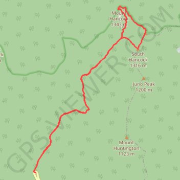
- Distance: 9.1 mi
- Elevation gain: 766 m
- Maximum elevation: 1,326 m
- Elevation loss: 767 m
- Minimum elevation: 646 m
- Moving time: 4 h 9 m
- Moving speed: 2.2 mph
- Maximum speed: 3.7 mph
- Total time: 5 h 14 m
- Global speed: 1.7 mph
Interactive trail map
Trail profile
- Distance: 9.1 mi
- Elevation gain: 766 m
- Maximum elevation: 1,326 m
- Elevation loss: 767 m
- Minimum elevation: 646 m
- Moving time: 4 h 9 m
- Moving speed: 2.2 mph
- Maximum speed: 3.7 mph
- Total time: 5 h 14 m
- Global speed: 1.7 mph
About this trail
Name: Mount Hancock, Middle Hancock and South Hancock Loop trail, distance, elevation, map, profile, GPS track
Coordinates: 44.04116 -71.52436 44.08411 -71.48409
Other hiking, mountain biking, running and outdoor activity trails
Click on a trail to view its statistics, map and profile.
Mount Hancock via Hancock Notch Trail and Hancock Loop Trail
United States > New Hampshire > Grafton County > Lincoln
The hike to Mount Hancock, Middle Hancock and South Hancock is a scenic journey through the White Mountain National Forest, offering lush forests and rewarding viewpoints. The initial stretch along the Hancock Notch Trail is a gentle introduction with stream crossings and serene woodlands, transitioning into…
Distance: 9.2 mi • Elevation gain: 777 m • Maximum elevation: 1,328 m