Import a GPX file

Meelup Loop

#Hiking #Loop

  • Distance: 5.5 mi
  • Elevation gain: 164 m
  • Maximum elevation: 110 m
  • Elevation loss: 164 m
  • Minimum elevation: 3 m

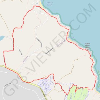
Interactive trail map

Trail profile

  • Distance: 5.5 mi
  • Elevation gain: 164 m
  • Maximum elevation: 110 m
  • Elevation loss: 164 m
  • Minimum elevation: 3 m

About this trail

Gear up for your next adventure:

🗺️Ordnance Survey Maps - Essential paper maps for hiking across the UK national parks
🧢Hiking Hats - Sun and weather protection for outdoor walks
📷Camera Straps - Secure straps for carrying cameras while walking
Insulated Travel Mugs - Keep drinks hot while surveying the landscape from a summit
📚UK Hiking Guidebooks - Detailed route descriptions for the Lake District, Peaks, and Highlands

As an Amazon Associate, this site earns from qualifying purchases at no extra cost to you.