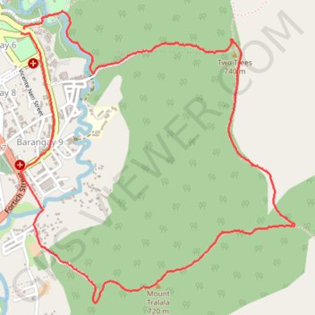
Two Trees and Mount Tralala Hiking Tour from Malaybalay
- Distance: 4.4 mi
- Elevation gain: 286 m
- Maximum elevation: 785 m
- Elevation loss: 285 m
- Minimum elevation: 586 m
- Moving time: 1 h 49 m
- Moving speed: 2.4 mph
- Maximum speed: 6.3 mph
- Total time: 2 h 4 m
- Global speed: 2.1 mph
Interactive trail map
Trail profile
- Distance: 4.4 mi
- Elevation gain: 286 m
- Maximum elevation: 785 m
- Elevation loss: 285 m
- Minimum elevation: 586 m
- Moving time: 1 h 49 m
- Moving speed: 2.4 mph
- Maximum speed: 6.3 mph
- Total time: 2 h 4 m
- Global speed: 2.1 mph
About this trail
Name: Two Trees and Mount Tralala Hiking Tour from Malaybalay trail, distance, elevation, map, profile, GPS track
Coordinates: 8.14080 125.13195 8.15762 125.14795