Make a donation
Gear up for your next adventure:
As an Amazon Associate, this site earns from qualifying purchases at no extra cost to you.
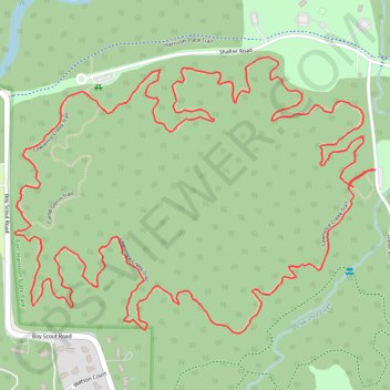
Lawrence Creek Loop Trail in Fort Harrison State Park
The Lawrence Creek Loop Trail offers a delightful escape into nature, featuring serene wooded areas and the gentle flow of Lawrence Creek. Hikers can enjoy a peaceful atmosphere, enriched by vibrant wildflowers in spring and stunning foliage during autumn. The trail is well-maintained, providing a pleasant experience for both casual walkers and more experienced hikers, while also accommodating mountain bikers. #Hiking #Loop #Forest #Nature
- Distance: 4.2 mi
- Elevation gain: 76 m
- Maximum elevation: 260 m
- Elevation loss: 75 m
- Minimum elevation: 229 m
- Moving time: 1 h 31 m
- Moving speed: 2.7 mph
- Maximum speed: 5.2 mph
- Total time: 1 h 31 m
- Global speed: 2.7 mph
Interactive trail map
Make a donation
Gear up for your next adventure:
As an Amazon Associate, this site earns from qualifying purchases at no extra cost to you.
Trail profile
- Distance: 4.2 mi
- Elevation gain: 76 m
- Maximum elevation: 260 m
- Elevation loss: 75 m
- Minimum elevation: 229 m
- Moving time: 1 h 31 m
- Moving speed: 2.7 mph
- Maximum speed: 5.2 mph
- Total time: 1 h 31 m
- Global speed: 2.7 mph
Make a donation
Gear up for your next adventure:
As an Amazon Associate, this site earns from qualifying purchases at no extra cost to you.
About this trail
Name: Lawrence Creek Loop Trail in Fort Harrison State Park trail, distance, elevation, map, profile, GPS track
Start: Glenn Road, Indianapolis, Marion County, Indiana, 46216, United States (39.86678 -86.02386)
Coordinates: 39.86232 -86.03670 39.86988 -86.02386
Make a donation
Gear up for your next adventure:
As an Amazon Associate, this site earns from qualifying purchases at no extra cost to you.