Make a donation
Gear up for your next adventure:
As an Amazon Associate, this site earns from qualifying purchases at no extra cost to you.
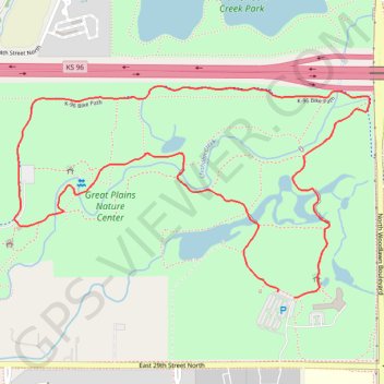
Chisholm Creek Park Loop in Great Plains Nature Center
The Chisholm Creek Park Loop offers a serene hiking experience through diverse ecosystems, including native prairies, wetlands, and woodlands. This well-maintained trail is ideal for observing a variety of wildlife, including birds and deer, making it a peaceful retreat within the city. #Hiking #Loop #Forest #Nature
- Distance: 2.3 mi
- Elevation gain: 15 m
- Maximum elevation: 418 m
- Elevation loss: 16 m
- Minimum elevation: 412 m
- Moving time: 37 m 3 s
- Moving speed: 3.7 mph
- Maximum speed: 4.2 mph
- Total time: 37 m 3 s
- Global speed: 3.7 mph
Interactive trail map
Make a donation
Gear up for your next adventure:
As an Amazon Associate, this site earns from qualifying purchases at no extra cost to you.
Trail profile
- Distance: 2.3 mi
- Elevation gain: 15 m
- Maximum elevation: 418 m
- Elevation loss: 16 m
- Minimum elevation: 412 m
- Moving time: 37 m 3 s
- Moving speed: 3.7 mph
- Maximum speed: 4.2 mph
- Total time: 37 m 3 s
- Global speed: 3.7 mph
Make a donation
Gear up for your next adventure:
As an Amazon Associate, this site earns from qualifying purchases at no extra cost to you.
About this trail
Name: Chisholm Creek Park Loop in Great Plains Nature Center trail, distance, elevation, map, profile, GPS track
Start: East 29th Street North, Wichita, Sedgwick County, Kansas, 67220, United States (37.73958 -97.26583)
End: East 29th Street North, Wichita, Sedgwick County, Kansas, 67220, United States (37.73943 -97.26527)
Coordinates: 37.73942 -97.27479 37.74510 -97.26270
Make a donation
Gear up for your next adventure:
As an Amazon Associate, this site earns from qualifying purchases at no extra cost to you.