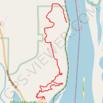
Hanging Rock Trail in Effigy Mounds National Monument
- Distance: 6.1 mi
- Elevation gain: 321 m
- Maximum elevation: 292 m
- Elevation loss: 327 m
- Minimum elevation: 203 m
- Moving time: 3 h 11 m
- Moving speed: 1.9 mph
- Maximum speed: 3.8 mph
- Total time: 3 h 59 m
- Global speed: 1.5 mph
Interactive trail map
Trail profile
- Distance: 6.1 mi
- Elevation gain: 321 m
- Maximum elevation: 292 m
- Elevation loss: 327 m
- Minimum elevation: 203 m
- Moving time: 3 h 11 m
- Moving speed: 1.9 mph
- Maximum speed: 3.8 mph
- Total time: 3 h 59 m
- Global speed: 1.5 mph
About this trail
Name: Hanging Rock Trail in Effigy Mounds National Monument trail, distance, elevation, map, profile, GPS track
Start: State Highway 76, Allamakee County, Iowa, 52146, United States (43.08882 -91.18659)
End: State Highway 76, Allamakee County, Iowa, 52146, United States (43.08883 -91.18550)
Coordinates: 43.08882 -91.18810 43.10982 -91.17896
Other hiking, mountain biking, running and outdoor activity trails
Click on a trail to view its statistics, map and profile.
Hanging Rock Trail in Effigy Mounds National Monument
United States > Iowa > Allamakee County
Distance: 5.9 mi • Elevation gain: 279 m • Maximum elevation: 292 m