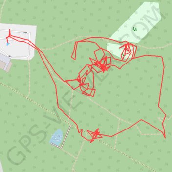
R TM000270
- Distance: 1.2 mi
- Elevation gain: 11 m
- Maximum elevation: 49 m
- Elevation loss: 11 m
- Minimum elevation: 42 m
- Moving time: 45 m 40 s
- Moving speed: 1.5 mph
- Maximum speed: 5.1 mph
- Total time: 2 h 2 m
- Global speed: 0.6 mph
Interactive trail map
Trail profile
- Distance: 1.2 mi
- Elevation gain: 11 m
- Maximum elevation: 49 m
- Elevation loss: 11 m
- Minimum elevation: 42 m
- Moving time: 45 m 40 s
- Moving speed: 1.5 mph
- Maximum speed: 5.1 mph
- Total time: 2 h 2 m
- Global speed: 0.6 mph
About this trail
Name: R TM000270 trail, distance, elevation, map, profile, GPS track
Coordinates: 51.90544 0.90475 51.90672 0.90767
Topography: Colchester topographic map, elevation, terrain