
Sunrise Trail to Sunrise Peak in McDowell Sonoran Preserve
The Sunrise Trail offers a scenic desert hike with sweeping views of the McDowell Mountains, Superstition Mountains, Four Peaks, and the Phoenix metropolitan area. The trail begins with a steady incline through classic Sonoran Desert terrain, where hikers can observe iconic saguaro cacti, unique rock formations, and occasional glimpses of wildlife like jackrabbits and desert birds. The final ascent to the peak is more challenging, featuring steep switchbacks that reward hikers with panoramic 360-degree views of the surrounding mountains and valleys, making it an ideal spot to witness the vibrant colors of sunrise or sunset. #Hiking #Mountain #Desert #Nature
- Distance: 3.7 mi
- Elevation gain: 355 m
- Maximum elevation: 921 m
- Elevation loss: 354 m
- Minimum elevation: 592 m
- Moving time: 1 h 40 m
- Moving speed: 2.2 mph
- Maximum speed: 3.7 mph
- Total time: 2 h 2 m
- Global speed: 1.8 mph
Interactive trail map
Trail profile
- Distance: 3.7 mi
- Elevation gain: 355 m
- Maximum elevation: 921 m
- Elevation loss: 354 m
- Minimum elevation: 592 m
- Moving time: 1 h 40 m
- Moving speed: 2.2 mph
- Maximum speed: 3.7 mph
- Total time: 2 h 2 m
- Global speed: 1.8 mph
About this trail
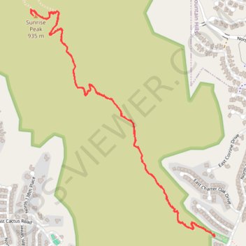
Name: Sunrise Trail to Sunrise Peak in McDowell Sonoran Preserve trail, distance, elevation, map, profile, GPS track
Coordinates: 33.59616 -111.78224 33.61051 -111.76824