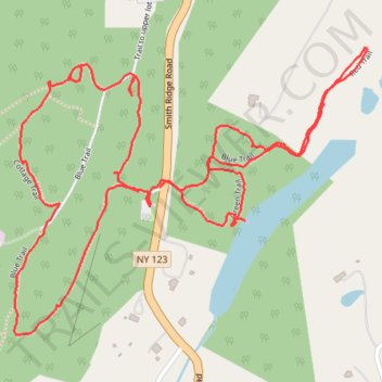
Leon Levy Preserve Trails
- Distance: 2.3 mi
- Elevation gain: 75 m
- Maximum elevation: 232 m
- Elevation loss: 70 m
- Minimum elevation: 179 m
- Moving time: 49 m 44 s
- Moving speed: 2.8 mph
- Maximum speed: 10.4 mph
- Total time: 1 h 27 m
- Global speed: 1.6 mph
Interactive trail map
Trail profile
- Distance: 2.3 mi
- Elevation gain: 75 m
- Maximum elevation: 232 m
- Elevation loss: 70 m
- Minimum elevation: 179 m
- Moving time: 49 m 44 s
- Moving speed: 2.8 mph
- Maximum speed: 10.4 mph
- Total time: 1 h 27 m
- Global speed: 1.6 mph
About this trail
Name: Leon Levy Preserve Trails trail, distance, elevation, map, profile, GPS track
Coordinates: 41.25685 -73.53391 41.26228 -73.52502
Other hiking, mountain biking, running and outdoor activity trails
Click on a trail to view its statistics, map and profile.