Greenburgh Nature Center Trails
- Distance: 4.0 mi
- Elevation gain: 67 m
- Maximum elevation: 111 m
- Elevation loss: 68 m
- Minimum elevation: 93 m
- Moving time: 1 h 6 m
- Moving speed: 3.6 mph
- Maximum speed: 5.7 mph
- Total time: 1 h 7 m
- Global speed: 3.6 mph
Interactive trail map
Trail profile
- Distance: 4.0 mi
- Elevation gain: 67 m
- Maximum elevation: 111 m
- Elevation loss: 68 m
- Minimum elevation: 93 m
- Moving time: 1 h 6 m
- Moving speed: 3.6 mph
- Maximum speed: 5.7 mph
- Total time: 1 h 7 m
- Global speed: 3.6 mph
About this trail
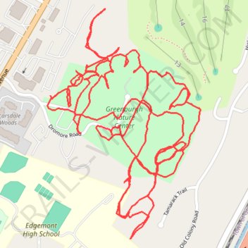
Name: Greenburgh Nature Center Trails trail, distance, elevation, map, profile, GPS track
Coordinates: 41.00136 -73.80970 41.00776 -73.80402
Other hiking, mountain biking, running and outdoor activity trails
Click on a trail to view its statistics, map and profile.
Bronx River Pathway
United States > New York > Westchester County > City of Yonkers
Distance: 13.8 mi • Elevation gain: 154 m • Maximum elevation: 56 m