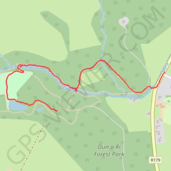
Dún a Rí Forest Park walk
- Distance: 1.4 mi
- Elevation gain: 14 m
- Maximum elevation: 95 m
- Elevation loss: 60 m
- Minimum elevation: 37 m
- Moving time: 33 m 1 s
- Moving speed: 2.5 mph
- Maximum speed: 3.8 mph
- Total time: 38 m 8 s
- Global speed: 2.2 mph
Interactive trail map
Trail profile
- Distance: 1.4 mi
- Elevation gain: 14 m
- Maximum elevation: 95 m
- Elevation loss: 60 m
- Minimum elevation: 37 m
- Moving time: 33 m 1 s
- Moving speed: 2.5 mph
- Maximum speed: 3.8 mph
- Total time: 38 m 8 s
- Global speed: 2.2 mph
About this trail
Name: Dún a Rí Forest Park walk trail, distance, elevation, map, profile, GPS track
Coordinates: 53.91885 -6.80114 53.92199 -6.78450
Other hiking, mountain biking, running and outdoor activity trails
Click on a trail to view its statistics, map and profile.
Dún a Rí Forest Park
Distance: 1.1 mi • Elevation gain: 64 m • Maximum elevation: 87 m