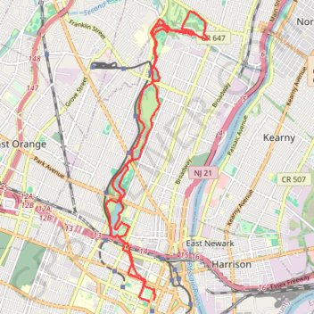
Branch Brook Park Loop
Afternoon Ride
- Distance: 11.1 mi
- Elevation gain: 155 m
- Maximum elevation: 48 m
- Elevation loss: 154 m
- Minimum elevation: 15 m
- Moving time: 1 h 7 m
- Moving speed: 9.8 mph
- Maximum speed: 24.2 mph
- Total time: 1 h 7 m
- Global speed: 9.8 mph
Interactive trail map
Trail profile
- Distance: 11.1 mi
- Elevation gain: 155 m
- Maximum elevation: 48 m
- Elevation loss: 154 m
- Minimum elevation: 15 m
- Moving time: 1 h 7 m
- Moving speed: 9.8 mph
- Maximum speed: 24.2 mph
- Total time: 1 h 7 m
- Global speed: 9.8 mph
About this trail
Name: Branch Brook Park Loop trail, distance, elevation, map, profile, GPS track
Coordinates: 40.73992 -74.18481 40.79005 -74.16163
Other hiking, mountain biking, running and outdoor activity trails
Click on a trail to view its statistics, map and profile.
Newark - Belleville
United States > New Jersey > Essex County > Newark > Roseville
Evening Ride
Distance: 11.3 mi • Elevation gain: 165 m • Maximum elevation: 48 m
Ironbound playground
United States > New Jersey > Essex County > Newark
Distance: 5.0 mi • Elevation gain: 66 m • Maximum elevation: 23 m
Ironbound, Harrison
United States > New Jersey > Essex County > Newark
Distance: 8.8 mi • Elevation gain: 128 m • Maximum elevation: 34 m
Cherry blossom
United States > New Jersey > Essex County > Newark
Evening Ride
Distance: 12.1 mi • Elevation gain: 163 m • Maximum elevation: 45 m
Afternoon Ride
United States > New Jersey > Essex County > Newark
Distance: 13.0 mi • Elevation gain: 198 m • Maximum elevation: 54 m
Cedar Grove
United States > New Jersey > Essex County > Newark
Afternoon Ride
Distance: 26.8 mi • Elevation gain: 399 m • Maximum elevation: 163 m