Divided from: Zeopoxa Cycling
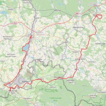
- Distance: 106.9 mi
- Elevation gain: 1,791 m
- Maximum elevation: 548 m
- Elevation loss: 1,806 m
- Minimum elevation: 162 m
Interactive trail map
Trail profile
- Distance: 106.9 mi
- Elevation gain: 1,791 m
- Maximum elevation: 548 m
- Elevation loss: 1,806 m
- Minimum elevation: 162 m
About this trail
Name: Divided from: Zeopoxa Cycling trail, distance, elevation, map, profile, GPS track
Coordinates: 50.85421 14.76869 51.26298 15.60175
Other hiking, mountain biking, running and outdoor activity trails
Click on a trail to view its statistics, map and profile.
Görlitz - Alpen
Germany > Saxony > Görlitz > Görlitz
Distance: 465.7 mi • Elevation gain: 5,160 m • Maximum elevation: 446 m
Görlitz - Alpen
Germany > Saxony > Görlitz > Görlitz
Distance: 465.7 mi • Elevation gain: 5,160 m • Maximum elevation: 446 m