Port Lavaca
Run
- Distance: 5.2 mi
- Elevation gain: 39 m
- Maximum elevation: 10 m
- Elevation loss: 39 m
- Minimum elevation: 0 m
- Moving time: 41 m 34 s
- Moving speed: 7.5 mph
- Maximum speed: 10.2 mph
- Total time: 41 m 34 s
- Global speed: 7.5 mph
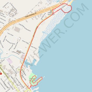
Interactive trail map
Trail profile
- Distance: 5.2 mi
- Elevation gain: 39 m
- Maximum elevation: 10 m
- Elevation loss: 39 m
- Minimum elevation: 0 m
- Moving time: 41 m 34 s
- Moving speed: 7.5 mph
- Maximum speed: 10.2 mph
- Total time: 41 m 34 s
- Global speed: 7.5 mph
About this trail
Name: Port Lavaca trail, distance, elevation, map, profile, GPS track
Start: Lighthouse Beach Road, Port Lavaca, Calhoun County, Texas, 77979, United States (28.63685 -96.61559)
End: Lighthouse Beach Road, Port Lavaca, Calhoun County, Texas, 77979, United States (28.63705 -96.61530)
Coordinates: 28.61648 -96.62642 28.63882 -96.61112
Other hiking, mountain biking, running and outdoor activity trails
Click on a trail to view its statistics, map and profile.
Port Lavaca Run
United States > Texas > Calhoun County > Port Lavaca
Distance: 5.4 mi • Elevation gain: 15 m • Maximum elevation: 10 m