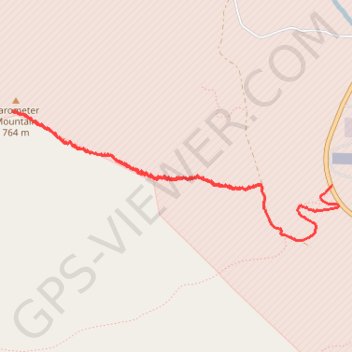
Barometer Mountain
- Distance: 2.9 mi
- Elevation gain: 731 m
- Maximum elevation: 750 m
- Elevation loss: 680 m
- Minimum elevation: 28 m
- Moving time: 2 h 14 m
- Moving speed: 1.3 mph
- Maximum speed: 4.6 mph
- Total time: 4 h 26 m
- Global speed: 0.6 mph
Interactive trail map
Trail profile
- Distance: 2.9 mi
- Elevation gain: 731 m
- Maximum elevation: 750 m
- Elevation loss: 680 m
- Minimum elevation: 28 m
- Moving time: 2 h 14 m
- Moving speed: 1.3 mph
- Maximum speed: 4.6 mph
- Total time: 4 h 26 m
- Global speed: 0.6 mph
About this trail
Name: Barometer Mountain trail, distance, elevation, map, profile, GPS track
Start: Rezanof Drive West, Aviation Hill, Kodiak Island, Alaska, 99619, United States (57.75079 -152.51911)
End: Burma Road, Kodiak Island, Alaska, 99619, United States (57.75089 -152.52564)
Coordinates: 57.74811 -152.54845 57.75446 -152.51850