Linear Trail
Interactive trail map
Trail profile
- Distance: 3.9 mi
- Elevation gain: 37 m
- Maximum elevation: 280 m
- Elevation loss: 37 m
- Minimum elevation: 268 m
About this trail
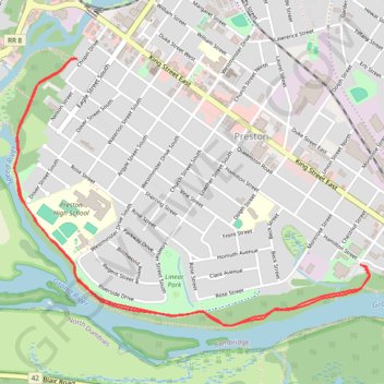
Name: Linear Trail trail, distance, elevation, map, profile, GPS track
Coordinates: 43.38525 -80.37052 43.39757 -80.34800
Other hiking, mountain biking, running and outdoor activity trails
Click on a trail to view its statistics, map and profile.
Aldershot - Kitchener
Canada > Ontario > Halton Region > Burlington
#Bike
Distance: 49.1 mi • Elevation gain: 570 m • Maximum elevation: 346 m