Sandstone Peak Loop via Backbone Trail and Mishe Mokwa Trail Loop
The Sandstone Peak Loop via Backbone Trail and Mishe Mokwa Trail offers hikers a journey through chaparral-covered hillsides, rugged sandstone formations, and shaded oak woodlands. Along the route, notable landmarks such as Split Rock and Balanced Rock provide unique geological interest, while vistas from Inspiration Point and Sandstone Peak—the highest point in the Santa Monica Mountains—afford expansive views of the surrounding mountains and the Pacific Ocean. This well-maintained trail is popular among hikers for its variety of terrains and panoramic scenery. #Hiking #Mountain #Forest #Nature #Loop #Rock #Overlook
- Distance: 6.2 mi
- Elevation gain: 438 m
- Maximum elevation: 922 m
- Elevation loss: 439 m
- Minimum elevation: 640 m
- Moving time: 2 h 37 m
- Moving speed: 2.3 mph
- Maximum speed: 5.1 mph
- Total time: 2 h 50 m
- Global speed: 2.2 mph
Interactive trail map
Trail profile
- Distance: 6.2 mi
- Elevation gain: 438 m
- Maximum elevation: 922 m
- Elevation loss: 439 m
- Minimum elevation: 640 m
- Moving time: 2 h 37 m
- Moving speed: 2.3 mph
- Maximum speed: 5.1 mph
- Total time: 2 h 50 m
- Global speed: 2.2 mph
About this trail
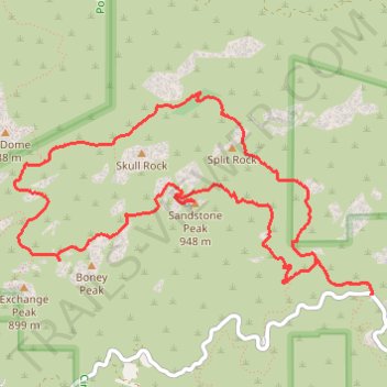
Name: Sandstone Peak Loop via Backbone Trail and Mishe Mokwa Trail Loop trail, distance, elevation, map, profile, GPS track
Start: Backbone Trail, Ventura County, California, United States (34.11427 -118.91825)
End: Yerba Buena Road, Ventura County, California, United States (34.11430 -118.91817)
Coordinates: 34.11427 -118.94638 34.12748 -118.91817
Other hiking, mountain biking, running and outdoor activity trails
Click on a trail to view its statistics, map and profile.
Sandstone Peak and Inspiration Point Loop via Backbone Trail and Mishe Mokwa Trail
United States > California > Ventura County
The Sandstone Peak and Inspiration Point Loop is a rewarding hike that combines scenic vistas and diverse rock formations. Along the route, you can admire sweeping views of the Santa Monica Mountains, with the option to extend your adventure to the remote Tri-Peaks and the unique Balanced Rock formations. The…
Distance: 6.1 mi • Elevation gain: 457 m • Maximum elevation: 922 m