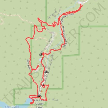
Moses Spring, Rim and High Peaks Trails Loop in Pinnacles National Park
The Moses Spring Trail, Rim Trail, and High Peaks Trail Loop in Pinnacles National Park offers hikers a diverse experience featuring talus caves, the Bear Gulch Reservoir, and panoramic vistas of the park's volcanic rock formations. Along the route, visitors can explore the Bear Gulch Cave, enjoy the view on top of Teaching Rock, ascend the Rim Trail, which provide sightings of the park's iconic spires and, with some luck, glimpses of California condors. This loop is celebrated for its variety of landscapes, including shaded woodlands, rugged rock formations, and open ridgelines, making it a favorite among hikers seeking both natural beauty and geological wonders. #Hiking #Forest #Nature #Loop #Rock #Lake #Cave
- Distance: 1.8 mi
- Elevation gain: 159 m
- Maximum elevation: 524 m
- Elevation loss: 156 m
- Minimum elevation: 410 m
- Moving time: 59 m 45 s
- Moving speed: 1.8 mph
- Maximum speed: 5.7 mph
- Total time: 1 h 20 m
- Global speed: 1.3 mph
Interactive trail map
Trail profile
- Distance: 1.8 mi
- Elevation gain: 159 m
- Maximum elevation: 524 m
- Elevation loss: 156 m
- Minimum elevation: 410 m
- Moving time: 59 m 45 s
- Moving speed: 1.8 mph
- Maximum speed: 5.7 mph
- Total time: 1 h 20 m
- Global speed: 1.3 mph
About this trail
Name: Moses Spring, Rim and High Peaks Trails Loop in Pinnacles National Park trail, distance, elevation, map, profile, GPS track
End: High Peaks Trail, San Benito County, California, United States (36.47838 -121.18369)
Coordinates: 36.47251 -121.18787 36.47845 -121.18369
Other hiking, mountain biking, running and outdoor activity trails
Click on a trail to view its statistics, map and profile.
Bear Gulch Cave Trail, High Peaks Trail and Condor Gulch Trail Loop
United States > California > San Benito County
The Bear Gulch Cave, High Peaks, and Condor Gulch trails offer a breathtaking loop through Pinnacles National Park, showcasing its striking volcanic formations, unique wildlife, and sweeping vistas. As you hike, you'll traverse narrow canyons, rocky spires, and expansive views, with the possibility of spotting…
Distance: 5.4 mi • Elevation gain: 492 m • Maximum elevation: 782 m