Baptism River High Falls via Superior Hiking Spur Trail in Tettegouche State Park
The hike to Baptism River High Falls provides an immersive journey through some of Minnesota's most scenic forestland. Starting near the visitor center, the trail meanders alongside the Baptism River, passing rocky outcroppings and tree-lined banks before reaching the 60-foot High Falls, the tallest waterfall entirely within the state. Views from the bridge over the falls and other vantage points reveal dramatic perspectives of the falls and river, enhanced by surrounding cliffs and lush forest, especially vibrant in autumn or serene and snow-dusted in winter. #Hiking #Waterfall #River #Forest #Nature
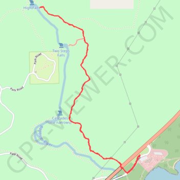
- Distance: 3.0 mi
- Elevation gain: 115 m
- Maximum elevation: 274 m
- Elevation loss: 115 m
- Minimum elevation: 199 m
- Moving time: 1 h 37 m
- Moving speed: 1.9 mph
- Maximum speed: 3.7 mph
- Total time: 2 h 12 m
- Global speed: 1.4 mph
Interactive trail map
Trail profile
- Distance: 3.0 mi
- Elevation gain: 115 m
- Maximum elevation: 274 m
- Elevation loss: 115 m
- Minimum elevation: 199 m
- Moving time: 1 h 37 m
- Moving speed: 1.9 mph
- Maximum speed: 3.7 mph
- Total time: 2 h 12 m
- Global speed: 1.4 mph
About this trail
Name: Baptism River High Falls via Superior Hiking Spur Trail in Tettegouche State Park trail, distance, elevation, map, profile, GPS track
Coordinates: 47.33751 -91.20902 47.35086 -91.19715