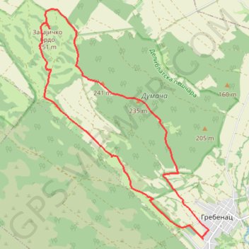
Zagajička Brda - Deliblatska peščara
- Distance: 9.3 mi
- Elevation gain: 250 m
- Maximum elevation: 243 m
- Elevation loss: 250 m
- Minimum elevation: 89 m
- Moving time: 4 h 17 m
- Moving speed: 2.2 mph
- Maximum speed: 3.1 mph
- Total time: 4 h 59 m
- Global speed: 1.9 mph
Interactive trail map
Trail profile
- Distance: 9.3 mi
- Elevation gain: 250 m
- Maximum elevation: 243 m
- Elevation loss: 250 m
- Minimum elevation: 89 m
- Moving time: 4 h 17 m
- Moving speed: 2.2 mph
- Maximum speed: 3.1 mph
- Total time: 4 h 59 m
- Global speed: 1.9 mph
About this trail
Name: Zagajička Brda - Deliblatska peščara trail, distance, elevation, map, profile, GPS track
Coordinates: 44.89736 21.18591 44.94229 21.23262
Other hiking, mountain biking, running and outdoor activity trails
Click on a trail to view its statistics, map and profile.
Grebenac - Zagajička brda
Serbia > Vojvodina > South Banat Administrative District > Bela Crkva Municipality > Grebenac
Distance: 9.1 mi • Elevation gain: 259 m • Maximum elevation: 243 m
2022_Yu
Slovenia > Ajdovščina > Žapuže
Distance: 1,526.9 mi • Elevation gain: 32,048 m • Maximum elevation: 1,950 m