Hermann Park Loop Walking
- Distance: 3.5 mi
- Elevation gain: 12 m
- Maximum elevation: 21 m
- Elevation loss: 14 m
- Minimum elevation: 15 m
- Moving time: 1 h 7 m
- Moving speed: 3.1 mph
- Maximum speed: 5.5 mph
- Total time: 1 h 24 m
- Global speed: 2.5 mph
Interactive trail map
Trail profile
- Distance: 3.5 mi
- Elevation gain: 12 m
- Maximum elevation: 21 m
- Elevation loss: 14 m
- Minimum elevation: 15 m
- Moving time: 1 h 7 m
- Moving speed: 3.1 mph
- Maximum speed: 5.5 mph
- Total time: 1 h 24 m
- Global speed: 2.5 mph
About this trail
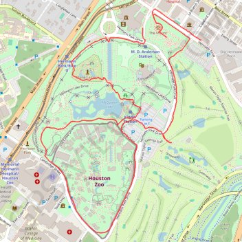
Name: Hermann Park Loop Walking trail, distance, elevation, map, profile, GPS track
Start: Caroline Street, Houston, Harris County, Texas, 77004, United States (29.72153 -95.38891)
Coordinates: 29.71054 -95.39520 29.72256 -95.38528