2024-10-31_17-16_Thu
- Distance: 3.4 mi
- Elevation gain: 83 m
- Maximum elevation: 50 m
- Elevation loss: 44 m
- Minimum elevation: 5 m
- Moving time: 20 m 49 s
- Moving speed: 9.8 mph
- Maximum speed: 25.6 mph
- Total time: 32 m 16 s
- Global speed: 6.3 mph
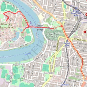
Interactive trail map
Trail profile
- Distance: 3.4 mi
- Elevation gain: 83 m
- Maximum elevation: 50 m
- Elevation loss: 44 m
- Minimum elevation: 5 m
- Moving time: 20 m 49 s
- Moving speed: 9.8 mph
- Maximum speed: 25.6 mph
- Total time: 32 m 16 s
- Global speed: 6.3 mph
About this trail
Name: 2024-10-31_17-16_Thu trail, distance, elevation, map, profile, GPS track
End: 426, Annerley Road, Annerley, Greater Brisbane, Queensland, 4103, Australia (-27.50841 153.03264)
Coordinates: -27.50841 153.01291 -27.49424 153.03264
Other hiking, mountain biking, running and outdoor activity trails
Click on a trail to view its statistics, map and profile.