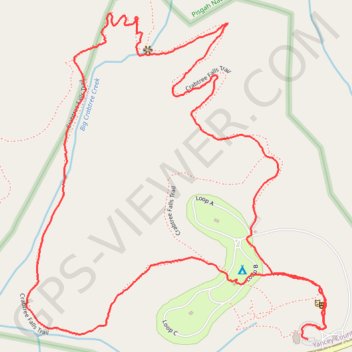
Crabtree Falls Loop Trail in Blue Ridge Parkway
The Crabtree Falls Loop Trail offers a beautiful and moderately challenging hike. As you descend through a lush oak-hickory forest, you'll pass over rocky sections, switchbacks, and a series of stone steps, all of which make the journey to the falls both scenic and rewarding. At the base, the waterfall cascades impressively over a rocky cliff, surrounded by vibrant ferns and wildflowers, creating an ideal spot for photography. For a more extended experience, continue along the loop to enjoy a more gradual ascent back through the forest and across Crabtree Creek. #Hiking #Loop #Waterfall #River #Forest #Nature
- Distance: 2.8 mi
- Elevation gain: 161 m
- Maximum elevation: 1,148 m
- Elevation loss: 157 m
- Minimum elevation: 1,014 m
- Moving time: 1 h 16 m
- Moving speed: 2.2 mph
- Maximum speed: 4.7 mph
- Total time: 1 h 38 m
- Global speed: 1.7 mph
Interactive trail map
Trail profile
- Distance: 2.8 mi
- Elevation gain: 161 m
- Maximum elevation: 1,148 m
- Elevation loss: 157 m
- Minimum elevation: 1,014 m
- Moving time: 1 h 16 m
- Moving speed: 2.2 mph
- Maximum speed: 4.7 mph
- Total time: 1 h 38 m
- Global speed: 1.7 mph
About this trail
Name: Crabtree Falls Loop Trail in Blue Ridge Parkway trail, distance, elevation, map, profile, GPS track
Start: Blue Ridge Parkway, Yancey County, North Carolina, United States (35.81234 -82.14381)
End: Blue Ridge Parkway, Yancey County, North Carolina, United States (35.81267 -82.14356)
Coordinates: 35.81234 -82.15290 35.82086 -82.14323
Other hiking, mountain biking, running and outdoor activity trails
Click on a trail to view its statistics, map and profile.
Crabtree Falls Loop Trail in Pisgah National Forest
United States > North Carolina > Yancey County
The Crabtree Falls Loop Trail, situated along the Blue Ridge Parkway in North Carolina, offers hikers a journey through a lush hardwood forest, leading to the base of a picturesque 70-foot cascade. Along the trail, one can observe diverse flora, including wildflowers in early summer and ferns near the…
Distance: 2.8 mi • Elevation gain: 160 m • Maximum elevation: 1,148 m
Comfort Suites Airport - Shady Valley Country Store
United States > Tennessee > Blount County > Alcoa > Farrport
146 mi, 2:28
Distance: 146.3 mi • Elevation gain: 3,292 m • Maximum elevation: 1,045 m