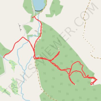
Paths near the Glack
- Distance: 2.2 mi
- Elevation gain: 122 m
- Maximum elevation: 284 m
- Elevation loss: 138 m
- Minimum elevation: 190 m
- Moving time: 50 m 13 s
- Moving speed: 2.6 mph
- Maximum speed: 15.2 mph
- Total time: 53 m 30 s
- Global speed: 2.5 mph
Interactive trail map
Trail profile
- Distance: 2.2 mi
- Elevation gain: 122 m
- Maximum elevation: 284 m
- Elevation loss: 138 m
- Minimum elevation: 190 m
- Moving time: 50 m 13 s
- Moving speed: 2.6 mph
- Maximum speed: 15.2 mph
- Total time: 53 m 30 s
- Global speed: 2.5 mph
About this trail
Name: Paths near the Glack trail, distance, elevation, map, profile, GPS track
Coordinates: 56.59123 -3.58462 56.59740 -3.56933
Topography: Perth and Kinross topographic map, elevation, terrain
Other hiking, mountain biking, running and outdoor activity trails
Click on a trail to view its statistics, map and profile.
Cally Loch Mountain Bike Ride, Dunkeld
United Kingdom > Scotland > Perth and Kinross
Distance: 24.1 mi • Elevation gain: 605 m • Maximum elevation: 189 m
Around Loch Ordie
United Kingdom > Scotland > Perth and Kinross
Mountain Bike Ride, UK, Perthshire, Dunkeld
Distance: 22.3 mi • Elevation gain: 579 m • Maximum elevation: 300 m