Thank you for supporting this site ❤️
Make a donation
Make a donation
Gear up for your next adventure:
As an Amazon Associate, this site earns from qualifying purchases at no extra cost to you.
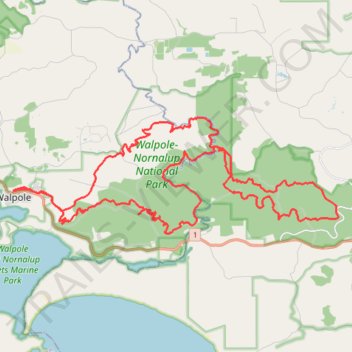
Walpole-Nornalup National Park MTB Loop
- Distance: 40.1 mi
- Elevation gain: 1,200 m
- Maximum elevation: 204 m
- Elevation loss: 1,198 m
- Minimum elevation: 4 m
- Moving time: 5 h 17 m
- Moving speed: 7.6 mph
- Maximum speed: 29.2 mph
- Total time: 6 h 32 m
- Global speed: 6.1 mph
Interactive trail map
Thank you for supporting this site ❤️
Make a donation
Make a donation
Gear up for your next adventure:
As an Amazon Associate, this site earns from qualifying purchases at no extra cost to you.
Trail profile
- Distance: 40.1 mi
- Elevation gain: 1,200 m
- Maximum elevation: 204 m
- Elevation loss: 1,198 m
- Minimum elevation: 4 m
- Moving time: 5 h 17 m
- Moving speed: 7.6 mph
- Maximum speed: 29.2 mph
- Total time: 6 h 32 m
- Global speed: 6.1 mph
Thank you for supporting this site ❤️
Make a donation
Make a donation
Gear up for your next adventure:
As an Amazon Associate, this site earns from qualifying purchases at no extra cost to you.
About this trail
Name: Walpole-Nornalup National Park MTB Loop trail, distance, elevation, map, profile, GPS track
Coordinates: -34.99207 116.73106 -34.94763 116.88247
Thank you for supporting this site ❤️
Make a donation
Make a donation
Gear up for your next adventure:
As an Amazon Associate, this site earns from qualifying purchases at no extra cost to you.