Thank you for supporting this site ❤️
Make a donation
Make a donation
Gear up for your next adventure:
As an Amazon Associate, this site earns from qualifying purchases at no extra cost to you.
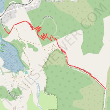
Coastal Connection
- Distance: 4.7 mi
- Elevation gain: 311 m
- Maximum elevation: 314 m
- Elevation loss: 311 m
- Minimum elevation: 31 m
- Moving time: 1 h 28 m
- Moving speed: 3.2 mph
- Maximum speed: 42.1 mph
- Total time: 1 h 28 m
- Global speed: 3.2 mph
Interactive trail map
Thank you for supporting this site ❤️
Make a donation
Make a donation
Gear up for your next adventure:
As an Amazon Associate, this site earns from qualifying purchases at no extra cost to you.
Trail profile
- Distance: 4.7 mi
- Elevation gain: 311 m
- Maximum elevation: 314 m
- Elevation loss: 311 m
- Minimum elevation: 31 m
- Moving time: 1 h 28 m
- Moving speed: 3.2 mph
- Maximum speed: 42.1 mph
- Total time: 1 h 28 m
- Global speed: 3.2 mph
Thank you for supporting this site ❤️
Make a donation
Make a donation
Gear up for your next adventure:
As an Amazon Associate, this site earns from qualifying purchases at no extra cost to you.
About this trail
Name: Coastal Connection trail, distance, elevation, map, profile, GPS track
Start: 5, Chelivode Street, Dunedin City, Otago, 9016, New Zealand (-45.74848 170.58212)
End: 5, Chelivode Street, Dunedin City, Otago, 9016, New Zealand (-45.74855 170.58219)
Coordinates: -45.75715 170.58212 -45.74750 170.60289
Thank you for supporting this site ❤️
Make a donation
Make a donation
Gear up for your next adventure:
As an Amazon Associate, this site earns from qualifying purchases at no extra cost to you.
Other hiking, mountain biking, running and outdoor activity trails
Click on a trail to view its statistics, map and profile.