Woowookarung Park with puppies to look at new tracks
Morning Walk
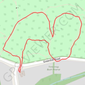
- Distance: 0.8 mi
- Elevation gain: 18 m
- Maximum elevation: 525 m
- Elevation loss: 18 m
- Minimum elevation: 508 m
- Moving time: 16 m 36 s
- Moving speed: 2.8 mph
- Maximum speed: 4.4 mph
- Total time: 16 m 36 s
- Global speed: 2.8 mph
Interactive trail map
Trail profile
- Distance: 0.8 mi
- Elevation gain: 18 m
- Maximum elevation: 525 m
- Elevation loss: 18 m
- Minimum elevation: 508 m
- Moving time: 16 m 36 s
- Moving speed: 2.8 mph
- Maximum speed: 4.4 mph
- Total time: 16 m 36 s
- Global speed: 2.8 mph
About this trail
Name: Woowookarung Park with puppies to look at new tracks trail, distance, elevation, map, profile, GPS track
Coordinates: -37.61770 143.88877 -37.61544 143.89250
Other hiking, mountain biking, running and outdoor activity trails
Click on a trail to view its statistics, map and profile.
Mount Helen Afternoon Walk
Australia > Victoria > Ballarat
Mapping tracks while walking dogs
Distance: 1.7 mi • Elevation gain: 49 m • Maximum elevation: 542 m