Thank you for supporting this site ❤️
Make a donation
Make a donation
Gear up for your next adventure:
As an Amazon Associate, this site earns from qualifying purchases at no extra cost to you.
Bicycle
- Distance: 8.3 mi
- Elevation gain: 68 m
- Maximum elevation: 1,685 m
- Elevation loss: 68 m
- Minimum elevation: 1,648 m
- Moving time: 57 m 28 s
- Moving speed: 8.7 mph
- Maximum speed: 13.6 mph
- Total time: 1 h 2 m
- Global speed: 8.0 mph
Interactive trail map
Thank you for supporting this site ❤️
Make a donation
Make a donation
Gear up for your next adventure:
As an Amazon Associate, this site earns from qualifying purchases at no extra cost to you.
Trail profile
- Distance: 8.3 mi
- Elevation gain: 68 m
- Maximum elevation: 1,685 m
- Elevation loss: 68 m
- Minimum elevation: 1,648 m
- Moving time: 57 m 28 s
- Moving speed: 8.7 mph
- Maximum speed: 13.6 mph
- Total time: 1 h 2 m
- Global speed: 8.0 mph
Thank you for supporting this site ❤️
Make a donation
Make a donation
Gear up for your next adventure:
As an Amazon Associate, this site earns from qualifying purchases at no extra cost to you.
About this trail
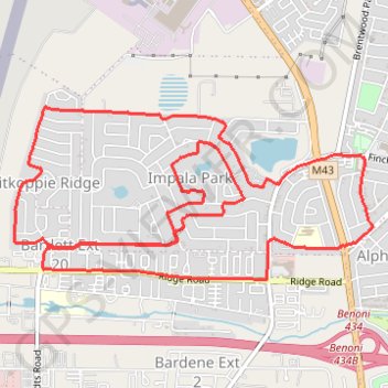
Name: Bicycle trail, distance, elevation, map, profile, GPS track
Coordinates: -26.16845 28.25273 -26.15615 28.28130
Thank you for supporting this site ❤️
Make a donation
Make a donation
Gear up for your next adventure:
As an Amazon Associate, this site earns from qualifying purchases at no extra cost to you.