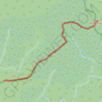
Kilohana Lookout
- Distance: 1.6 mi
- Elevation gain: 43 m
- Maximum elevation: 1,234 m
- Elevation loss: 29 m
- Minimum elevation: 1,195 m
- Moving time: 48 m 19 s
- Moving speed: 1.9 mph
- Maximum speed: 4.1 mph
- Total time: 56 m 55 s
- Global speed: 1.7 mph
Interactive trail map
Trail profile
- Distance: 1.6 mi
- Elevation gain: 43 m
- Maximum elevation: 1,234 m
- Elevation loss: 29 m
- Minimum elevation: 1,195 m
- Moving time: 48 m 19 s
- Moving speed: 1.9 mph
- Maximum speed: 4.1 mph
- Total time: 56 m 55 s
- Global speed: 1.7 mph
About this trail
Name: Kilohana Lookout trail, distance, elevation, map, profile, GPS track
Start: Alaka'i Swamp Trail, Kauaʻi County, Hawaii, United States (22.14720 -159.60899)
End: Alaka'i Swamp Trail, Kauaʻi County, Hawaii, United States (22.15632 -159.59375)
Coordinates: 22.14720 -159.60899 22.15632 -159.59375