Make a donation
Gear up for your next adventure:
As an Amazon Associate, this site earns from qualifying purchases at no extra cost to you.
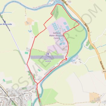
Saltford Water Recycling Bridge
Saltford, Water, Recycling, Bridge
- Distance: 2.6 mi
- Elevation gain: 30 m
- Maximum elevation: 30 m
- Elevation loss: 29 m
- Minimum elevation: 10 m
- Moving time: 29 m 57 s
- Moving speed: 5.2 mph
- Maximum speed: 14.8 mph
- Total time: 1 h 9 m
- Global speed: 2.3 mph
Interactive trail map
Make a donation
Gear up for your next adventure:
As an Amazon Associate, this site earns from qualifying purchases at no extra cost to you.
Trail profile
- Distance: 2.6 mi
- Elevation gain: 30 m
- Maximum elevation: 30 m
- Elevation loss: 29 m
- Minimum elevation: 10 m
- Moving time: 29 m 57 s
- Moving speed: 5.2 mph
- Maximum speed: 14.8 mph
- Total time: 1 h 9 m
- Global speed: 2.3 mph
Make a donation
Gear up for your next adventure:
As an Amazon Associate, this site earns from qualifying purchases at no extra cost to you.
About this trail
Name: Saltford Water Recycling Bridge trail, distance, elevation, map, profile, GPS track
Coordinates: 51.40358 -2.45238 51.41815 -2.44001
Topography: Bath and North East Somerset topographic map, elevation, terrain
Make a donation
Gear up for your next adventure:
As an Amazon Associate, this site earns from qualifying purchases at no extra cost to you.
Other hiking, mountain biking, running and outdoor activity trails
Click on a trail to view its statistics, map and profile.
2024-03-30_10-35_Sat
United Kingdom > England > City of Bristol > Bristol
Distance: 13.3 mi • Elevation gain: 200 m • Maximum elevation: 59 m