Thank you for supporting this site ❤️
Make a donation
Make a donation
Gear up for your next adventure:
As an Amazon Associate, this site earns from qualifying purchases at no extra cost to you.
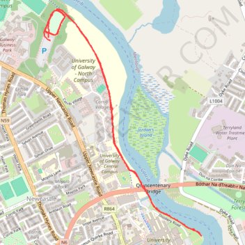
University Of Galway parkrun jog/walk
- Distance: 3.6 mi
- Elevation gain: 14 m
- Maximum elevation: 11 m
- Elevation loss: 14 m
- Minimum elevation: 3 m
- Moving time: 44 m 19 s
- Moving speed: 4.8 mph
- Maximum speed: 18.1 mph
- Total time: 44 m 19 s
- Global speed: 4.8 mph
Interactive trail map
Thank you for supporting this site ❤️
Make a donation
Make a donation
Gear up for your next adventure:
As an Amazon Associate, this site earns from qualifying purchases at no extra cost to you.
Trail profile
- Distance: 3.6 mi
- Elevation gain: 14 m
- Maximum elevation: 11 m
- Elevation loss: 14 m
- Minimum elevation: 3 m
- Moving time: 44 m 19 s
- Moving speed: 4.8 mph
- Maximum speed: 18.1 mph
- Total time: 44 m 19 s
- Global speed: 4.8 mph
Thank you for supporting this site ❤️
Make a donation
Make a donation
Gear up for your next adventure:
As an Amazon Associate, this site earns from qualifying purchases at no extra cost to you.
About this trail
Name: University Of Galway parkrun jog/walk trail, distance, elevation, map, profile, GPS track
Coordinates: 53.27992 -9.07110 53.29286 -9.05607
Thank you for supporting this site ❤️
Make a donation
Make a donation
Gear up for your next adventure:
As an Amazon Associate, this site earns from qualifying purchases at no extra cost to you.