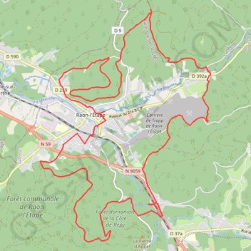
Autour de Raon l'Etape
- Distance: 19.7 mi
- Elevation gain: 798 m
- Maximum elevation: 557 m
- Elevation loss: 798 m
- Minimum elevation: 282 m
Interactive trail map
Trail profile
- Distance: 19.7 mi
- Elevation gain: 798 m
- Maximum elevation: 557 m
- Elevation loss: 798 m
- Minimum elevation: 282 m
About this trail
Name: Autour de Raon l'Etape trail, distance, elevation, map, profile, GPS track
Coordinates: 48.37491 6.82456 48.43346 6.88929
Other hiking, mountain biking, running and outdoor activity trails
Click on a trail to view its statistics, map and profile.
Track vom: 2020-06-13 07:00
Germany > North Rhine-Westphalia > Kreis Wesel > Schermbeck
Distance: 422.5 mi • Elevation gain: 5,301 m • Maximum elevation: 921 m
Track vom: 2020-06-27 07:26
Germany > Bavaria > Landkreis Ostallgäu > Halblech
Distance: 427.6 mi • Elevation gain: 4,307 m • Maximum elevation: 911 m
Riethoven naar Oostenrijk
Netherlands > North Brabant > Riethoven > Eind
Distance: 573.0 mi • Elevation gain: 13,629 m • Maximum elevation: 1,897 m