Thank you for supporting this site ❤️
Make a donation
Make a donation
Gear up for your next adventure:
As an Amazon Associate, this site earns from qualifying purchases at no extra cost to you.
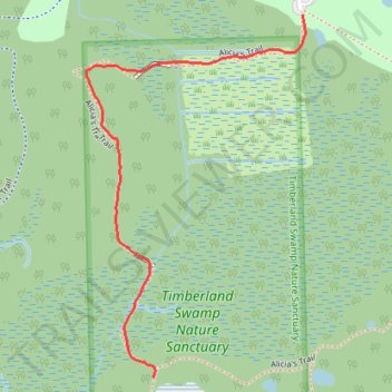
Trail in Timberland Nature Sanctuary in Springfield Township, MI
- Distance: 0.7 mi
- Elevation gain: 9 m
- Maximum elevation: 314 m
- Elevation loss: 7 m
- Minimum elevation: 307 m
- Moving time: 23 m 36 s
- Moving speed: 1.8 mph
- Maximum speed: 9.1 mph
- Total time: 30 m 20 s
- Global speed: 1.4 mph
Interactive trail map
Thank you for supporting this site ❤️
Make a donation
Make a donation
Gear up for your next adventure:
As an Amazon Associate, this site earns from qualifying purchases at no extra cost to you.
Trail profile
- Distance: 0.7 mi
- Elevation gain: 9 m
- Maximum elevation: 314 m
- Elevation loss: 7 m
- Minimum elevation: 307 m
- Moving time: 23 m 36 s
- Moving speed: 1.8 mph
- Maximum speed: 9.1 mph
- Total time: 30 m 20 s
- Global speed: 1.4 mph
Thank you for supporting this site ❤️
Make a donation
Make a donation
Gear up for your next adventure:
As an Amazon Associate, this site earns from qualifying purchases at no extra cost to you.
About this trail
Name: Trail in Timberland Nature Sanctuary in Springfield Township, MI trail, distance, elevation, map, profile, GPS track
Coordinates: 42.71712 -83.49635 42.72317 -83.49138
Thank you for supporting this site ❤️
Make a donation
Make a donation
Gear up for your next adventure:
As an Amazon Associate, this site earns from qualifying purchases at no extra cost to you.