Make a donation
Gear up for your next adventure:
As an Amazon Associate, this site earns from qualifying purchases at no extra cost to you.
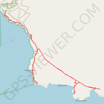
La Perouse Bay and King's Highway (Maui Island)
Hike along La Perouse Bay (Keoneʻōʻio Bay) and King's Highway from Keoneʻōʻio via Hoapali Trail, King's Highway and Hanamanioa Point Light on Maui Island. #Hiking #Sea #Pacific #Ocean #Volcano #Island #Hawaii #Nature #Mountain
- Distance: 6.7 mi
- Elevation gain: 138 m
- Maximum elevation: 23 m
- Elevation loss: 138 m
- Minimum elevation: 0 m
- Moving time: 2 h 53 m
- Moving speed: 2.3 mph
- Maximum speed: 3.4 mph
- Total time: 3 h 51 m
- Global speed: 1.7 mph
Interactive trail map
Make a donation
Gear up for your next adventure:
As an Amazon Associate, this site earns from qualifying purchases at no extra cost to you.
Trail profile
- Distance: 6.7 mi
- Elevation gain: 138 m
- Maximum elevation: 23 m
- Elevation loss: 138 m
- Minimum elevation: 0 m
- Moving time: 2 h 53 m
- Moving speed: 2.3 mph
- Maximum speed: 3.4 mph
- Total time: 3 h 51 m
- Global speed: 1.7 mph
Make a donation
Gear up for your next adventure:
As an Amazon Associate, this site earns from qualifying purchases at no extra cost to you.
About this trail
Name: La Perouse Bay and King's Highway (Maui Island) trail, distance, elevation, map, profile, GPS track
Start: Makena Alanui, Kanahena, Maui County, Hawaii, United States (20.60056 -156.41976)
End: Makena Alanui, Kanahena, Maui County, Hawaii, United States (20.60069 -156.41978)
Coordinates: 20.58089 -156.42032 20.60069 -156.39602
Make a donation
Gear up for your next adventure:
As an Amazon Associate, this site earns from qualifying purchases at no extra cost to you.