Import a GPX file

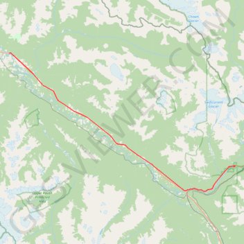
McBride - Mount Robson Provincial Park

#Bike #McBride #Robson

  • Distance: 48.3 mi
  • Elevation gain: 806 m
  • Maximum elevation: 897 m
  • Elevation loss: 689 m
  • Minimum elevation: 713 m

Interactive trail map

Trail profile

  • Distance: 48.3 mi
  • Elevation gain: 806 m
  • Maximum elevation: 897 m
  • Elevation loss: 689 m
  • Minimum elevation: 713 m

About this trail

Other hiking, mountain biking, running and outdoor activity trails

Click on a trail to view its statistics, map and profile.

Mount Robson Provincial Park - Jasper

Canada > British Columbia > Regional District of Fraser-Fort George > Area H (Robson Valley/Canoe)

#Bike #Robson #Jasper

Distance: 57.3 mi • Elevation gain: 1,010 m • Maximum elevation: 1,172 m

Gear up for your next adventure:

🧭Orienteering Compasses - Accurate compasses for map-based navigation
🛰️Satellite Messengers - Emergency communication devices for areas without mobile signal
🧗Locking Carabiners - Secure gear to your pack or for light technical use
🚲Cycling GPS Computers - Track elevation and topographic routes on two wheels
🐕Dog Hiking Gear - Equipment for hiking safely with dogs

As an Amazon Associate, this site earns from qualifying purchases at no extra cost to you.