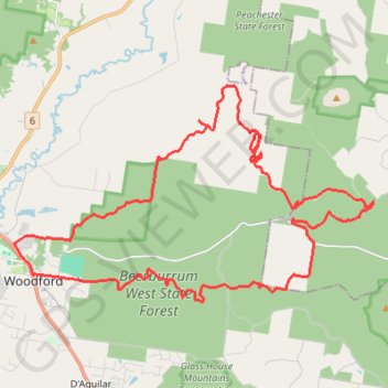
Woodford - Beerburrum West State Forest
#MTB #Loop #Beerburrum
- Distance: 28.8 mi
- Elevation gain: 697 m
- Maximum elevation: 212 m
- Elevation loss: 698 m
- Minimum elevation: 47 m
Interactive trail map
Trail profile
- Distance: 28.8 mi
- Elevation gain: 697 m
- Maximum elevation: 212 m
- Elevation loss: 698 m
- Minimum elevation: 47 m
About this trail
Name: Woodford - Beerburrum West State Forest trail, distance, elevation, map, profile, GPS track
Coordinates: -26.96161 152.77104 -26.89346 152.89781
Other hiking, mountain biking, running and outdoor activity trails
Click on a trail to view its statistics, map and profile.
2026-07-14_02-27_Tue
Australia > Queensland > Brisbane
Distance: 252.4 mi • Elevation gain: 3,756 m • Maximum elevation: 171 m
Hennessey Hill GPS Trace
Australia > Queensland > Sunshine Coast Regional
Distance: 1.5 mi • Elevation gain: 104 m • Maximum elevation: 172 m