Union University MTB ride
- Distance: 7.5 mi
- Elevation gain: 95 m
- Maximum elevation: 149 m
- Elevation loss: 96 m
- Minimum elevation: 124 m
- Moving time: 55 m 49 s
- Moving speed: 8.1 mph
- Maximum speed: 17.8 mph
- Total time: 56 m 52 s
- Global speed: 7.9 mph
Interactive trail map
Trail profile
- Distance: 7.5 mi
- Elevation gain: 95 m
- Maximum elevation: 149 m
- Elevation loss: 96 m
- Minimum elevation: 124 m
- Moving time: 55 m 49 s
- Moving speed: 8.1 mph
- Maximum speed: 17.8 mph
- Total time: 56 m 52 s
- Global speed: 7.9 mph
About this trail
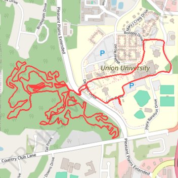
Name: Union University MTB ride trail, distance, elevation, map, profile, GPS track
Coordinates: 35.67163 -88.87222 35.67930 -88.85655
Other hiking, mountain biking, running and outdoor activity trails
Click on a trail to view its statistics, map and profile.
Gmaps Pedometer Route
United States > Kentucky > Fulton County > Hickman
Distance: 312.5 mi • Elevation gain: 4,204 m • Maximum elevation: 592 m