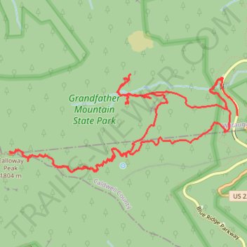
Calloway Peak loop via Nuwati Trail, Storyteller Rock, Cragway Trail, Top Crag View, Flat Rock View and Daniel Boone Scout Trail in Grandfather Mountain State Park
- Distance: 8.6 mi
- Elevation gain: 723 m
- Maximum elevation: 1,786 m
- Elevation loss: 690 m
- Minimum elevation: 1,194 m
- Moving time: 3 h 46 m
- Moving speed: 2.3 mph
- Maximum speed: 34.5 mph
- Total time: 4 h 53 m
- Global speed: 1.8 mph
Interactive trail map
Trail profile
- Distance: 8.6 mi
- Elevation gain: 723 m
- Maximum elevation: 1,786 m
- Elevation loss: 690 m
- Minimum elevation: 1,194 m
- Moving time: 3 h 46 m
- Moving speed: 2.3 mph
- Maximum speed: 34.5 mph
- Total time: 4 h 53 m
- Global speed: 1.8 mph
About this trail
Name: Calloway Peak loop via Nuwati Trail, Storyteller Rock, Cragway Trail, Top Crag View, Flat Rock View and Daniel Boone Scout Trail in Grandfather Mountain State Park trail, distance, elevation, map, profile, GPS track
Start: Boone Fork Parking Area, Watauga County, North Carolina, United States (36.11969 -81.78137)
End: Blue Ridge Parkway, Watauga County, North Carolina, United States (36.11564 -81.77939)
Coordinates: 36.10943 -81.81044 36.12020 -81.77932
Other hiking, mountain biking, running and outdoor activity trails
Click on a trail to view its statistics, map and profile.
Calloway Peak Hike
United States > North Carolina > Watauga County
Distance: 10.3 mi • Elevation gain: 753 m • Maximum elevation: 1,787 m