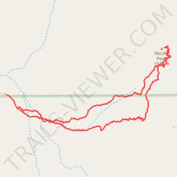
Nicolls Peak loop
- Distance: 3.0 mi
- Elevation gain: 582 m
- Maximum elevation: 1,821 m
- Elevation loss: 603 m
- Minimum elevation: 1,217 m
- Moving time: 2 h 19 m
- Moving speed: 1.3 mph
- Maximum speed: 3.0 mph
- Total time: 6 h 8 m
- Global speed: 0.5 mph
Interactive trail map
Trail profile
- Distance: 3.0 mi
- Elevation gain: 582 m
- Maximum elevation: 1,821 m
- Elevation loss: 603 m
- Minimum elevation: 1,217 m
- Moving time: 2 h 19 m
- Moving speed: 1.3 mph
- Maximum speed: 3.0 mph
- Total time: 6 h 8 m
- Global speed: 0.5 mph
About this trail
Name: Nicolls Peak loop trail, distance, elevation, map, profile, GPS track
Start: Kern County, California, United States (35.61496 -118.31186)
End: Kern County, California, United States (35.61605 -118.31300)
Coordinates: 35.61326 -118.31300 35.61983 -118.29727