Make a donation
Gear up for your next adventure:
As an Amazon Associate, this site earns from qualifying purchases at no extra cost to you.
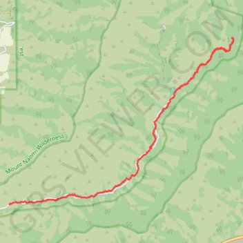
Green Canyon Trail
- Distance: 6.9 mi
- Elevation gain: 248 m
- Maximum elevation: 2,036 m
- Elevation loss: 545 m
- Minimum elevation: 1,578 m
- Moving time: 1 h 31 s
- Moving speed: 6.9 mph
- Maximum speed: 28.2 mph
- Total time: 1 h 10 m
- Global speed: 5.9 mph
Interactive trail map
Make a donation
Gear up for your next adventure:
As an Amazon Associate, this site earns from qualifying purchases at no extra cost to you.
Trail profile
- Distance: 6.9 mi
- Elevation gain: 248 m
- Maximum elevation: 2,036 m
- Elevation loss: 545 m
- Minimum elevation: 1,578 m
- Moving time: 1 h 31 s
- Moving speed: 6.9 mph
- Maximum speed: 28.2 mph
- Total time: 1 h 10 m
- Global speed: 5.9 mph
Make a donation
Gear up for your next adventure:
As an Amazon Associate, this site earns from qualifying purchases at no extra cost to you.
About this trail
Name: Green Canyon Trail trail, distance, elevation, map, profile, GPS track
Start: Green Canyon Trail, Cache County, Utah, United States (41.79466 -111.71922)
End: Green Canyon Road, Cache County, Utah, United States (41.76972 -111.76800)
Coordinates: 41.76972 -111.76800 41.80589 -111.70262
Make a donation
Gear up for your next adventure:
As an Amazon Associate, this site earns from qualifying purchases at no extra cost to you.
Other hiking, mountain biking, running and outdoor activity trails
Click on a trail to view its statistics, map and profile.
Uinta-Wasatch-Cache National Forest
United States > Utah > Cache County
Distance: 5.5 mi • Elevation gain: 63 m • Maximum elevation: 1,744 m