Thank you for supporting this site ❤️
Make a donation
Make a donation
Gear up for your next adventure:
As an Amazon Associate, this site earns from qualifying purchases at no extra cost to you.
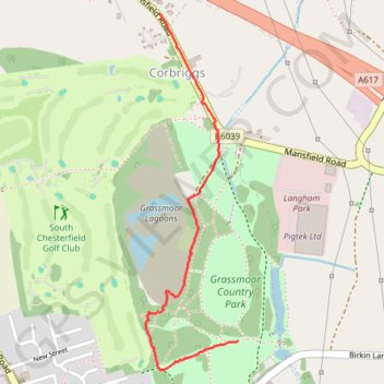
Grassmoor Country Park
- Distance: 1.1 mi
- Elevation gain: 20 m
- Maximum elevation: 128 m
- Elevation loss: 34 m
- Minimum elevation: 96 m
- Moving time: 22 m 51 s
- Moving speed: 2.8 mph
- Maximum speed: 24.2 mph
- Total time: 24 m
- Global speed: 2.7 mph
Interactive trail map
Thank you for supporting this site ❤️
Make a donation
Make a donation
Gear up for your next adventure:
As an Amazon Associate, this site earns from qualifying purchases at no extra cost to you.
Trail profile
- Distance: 1.1 mi
- Elevation gain: 20 m
- Maximum elevation: 128 m
- Elevation loss: 34 m
- Minimum elevation: 96 m
- Moving time: 22 m 51 s
- Moving speed: 2.8 mph
- Maximum speed: 24.2 mph
- Total time: 24 m
- Global speed: 2.7 mph
Thank you for supporting this site ❤️
Make a donation
Make a donation
Gear up for your next adventure:
As an Amazon Associate, this site earns from qualifying purchases at no extra cost to you.
About this trail
Name: Grassmoor Country Park trail, distance, elevation, map, profile, GPS track
Coordinates: 53.20043 -1.39023 53.21096 -1.38566
Topography: North East Derbyshire topographic map, elevation, terrain
Thank you for supporting this site ❤️
Make a donation
Make a donation
Gear up for your next adventure:
As an Amazon Associate, this site earns from qualifying purchases at no extra cost to you.