Thank you for supporting this site ❤️
Make a donation
Make a donation
Gear up for your next adventure:
As an Amazon Associate, this site earns from qualifying purchases at no extra cost to you.
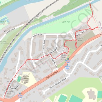
Holburne Park
Holburne, Park
- Distance: 0.6 mi
- Elevation gain: 39 m
- Maximum elevation: 66 m
- Elevation loss: 31 m
- Minimum elevation: 35 m
- Moving time: 19 m 6 s
- Moving speed: 2.0 mph
- Maximum speed: 6.1 mph
- Total time: 20 m 2 s
- Global speed: 1.9 mph
Interactive trail map
Thank you for supporting this site ❤️
Make a donation
Make a donation
Gear up for your next adventure:
As an Amazon Associate, this site earns from qualifying purchases at no extra cost to you.
Trail profile
- Distance: 0.6 mi
- Elevation gain: 39 m
- Maximum elevation: 66 m
- Elevation loss: 31 m
- Minimum elevation: 35 m
- Moving time: 19 m 6 s
- Moving speed: 2.0 mph
- Maximum speed: 6.1 mph
- Total time: 20 m 2 s
- Global speed: 1.9 mph
Thank you for supporting this site ❤️
Make a donation
Make a donation
Gear up for your next adventure:
As an Amazon Associate, this site earns from qualifying purchases at no extra cost to you.
About this trail
Name: Holburne Park trail, distance, elevation, map, profile, GPS track
Coordinates: 51.38746 -2.34728 51.39164 -2.34055
Topography: Bath topographic map, elevation, terrain
Thank you for supporting this site ❤️
Make a donation
Make a donation
Gear up for your next adventure:
As an Amazon Associate, this site earns from qualifying purchases at no extra cost to you.