Thank you for supporting this site ❤️
Make a donation
Make a donation
Gear up for your next adventure:
As an Amazon Associate, this site earns from qualifying purchases at no extra cost to you.
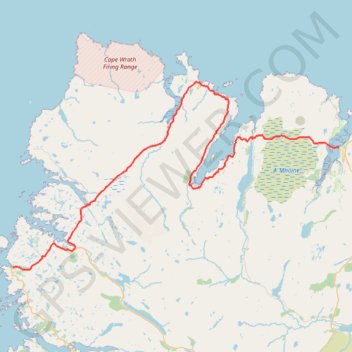
North West Highlands Geopark
- Distance: 53.6 mi
- Elevation gain: 1,184 m
- Maximum elevation: 227 m
- Elevation loss: 1,189 m
- Minimum elevation: 0 m
- Moving time: 6 h 17 m
- Moving speed: 8.5 mph
- Maximum speed: 33.9 mph
- Total time: 8 h 2 m
- Global speed: 6.7 mph
Interactive trail map
Thank you for supporting this site ❤️
Make a donation
Make a donation
Gear up for your next adventure:
As an Amazon Associate, this site earns from qualifying purchases at no extra cost to you.
Trail profile
- Distance: 53.6 mi
- Elevation gain: 1,184 m
- Maximum elevation: 227 m
- Elevation loss: 1,189 m
- Minimum elevation: 0 m
- Moving time: 6 h 17 m
- Moving speed: 8.5 mph
- Maximum speed: 33.9 mph
- Total time: 8 h 2 m
- Global speed: 6.7 mph
Thank you for supporting this site ❤️
Make a donation
Make a donation
Gear up for your next adventure:
As an Amazon Associate, this site earns from qualifying purchases at no extra cost to you.
About this trail
Name: North West Highlands Geopark trail, distance, elevation, map, profile, GPS track
End: A838, Tongue, Highland, Scotland, IV27 4XH, United Kingdom (58.49200 -4.42731)
Coordinates: 58.34857 -5.15629 58.56865 -4.42731
Topography: Highland topographic map, elevation, terrain
Thank you for supporting this site ❤️
Make a donation
Make a donation
Gear up for your next adventure:
As an Amazon Associate, this site earns from qualifying purchases at no extra cost to you.