Pooteering around Edinchip
Walk around Edinchip
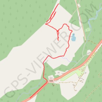
- Distance: 1.8 mi
- Elevation gain: 25 m
- Maximum elevation: 204 m
- Elevation loss: 86 m
- Minimum elevation: 141 m
- Moving time: 51 m 52 s
- Moving speed: 2.1 mph
- Maximum speed: 35.2 mph
- Total time: 1 h 1 m
- Global speed: 1.7 mph
Interactive trail map
Trail profile
- Distance: 1.8 mi
- Elevation gain: 25 m
- Maximum elevation: 204 m
- Elevation loss: 86 m
- Minimum elevation: 141 m
- Moving time: 51 m 52 s
- Moving speed: 2.1 mph
- Maximum speed: 35.2 mph
- Total time: 1 h 1 m
- Global speed: 1.7 mph
About this trail
Name: Pooteering around Edinchip trail, distance, elevation, map, profile, GPS track
Start: Kingshouse, Stirling, Scotland, FK19 8NZ, United Kingdom (56.36579 -4.31392)
End: A84, Kingshouse, Stirling, Scotland, FK19 8NX, United Kingdom (56.35753 -4.31717)
Coordinates: 56.35753 -4.31717 56.36782 -4.30888
Topography: Stirling topographic map, elevation, terrain
Other hiking, mountain biking, running and outdoor activity trails
Click on a trail to view its statistics, map and profile.