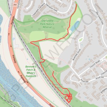
Bishop's Knoll - Old Sneed Park Nature Reserve
- Distance: 1.0 mi
- Elevation gain: 43 m
- Maximum elevation: 40 m
- Elevation loss: 45 m
- Minimum elevation: 14 m
- Moving time: 38 m 22 s
- Moving speed: 1.6 mph
- Maximum speed: 3.9 mph
- Total time: 51 m 2 s
- Global speed: 1.2 mph
Interactive trail map
Trail profile
- Distance: 1.0 mi
- Elevation gain: 43 m
- Maximum elevation: 40 m
- Elevation loss: 45 m
- Minimum elevation: 14 m
- Moving time: 38 m 22 s
- Moving speed: 1.6 mph
- Maximum speed: 3.9 mph
- Total time: 51 m 2 s
- Global speed: 1.2 mph
About this trail
Name: Bishop's Knoll - Old Sneed Park Nature Reserve trail, distance, elevation, map, profile, GPS track
Coordinates: 51.47195 -2.64676 51.47793 -2.64230
Topography: Bristol topographic map, elevation, terrain
Other hiking, mountain biking, running and outdoor activity trails
Click on a trail to view its statistics, map and profile.
Dean2023-311
United Kingdom > England > Oxfordshire > Oxford
Distance: 192.8 mi • Elevation gain: 3,366 m • Maximum elevation: 290 m