Cap2Cap 2021
Great day
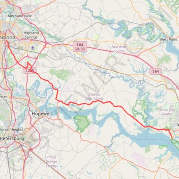
- Distance: 52.5 mi
- Elevation gain: 391 m
- Maximum elevation: 51 m
- Elevation loss: 395 m
- Minimum elevation: 2 m
- Moving time: 4 h 26 m
- Moving speed: 11.8 mph
- Maximum speed: 27.3 mph
- Total time: 4 h 59 m
- Global speed: 10.5 mph
Interactive trail map
Trail profile
- Distance: 52.5 mi
- Elevation gain: 391 m
- Maximum elevation: 51 m
- Elevation loss: 395 m
- Minimum elevation: 2 m
- Moving time: 4 h 26 m
- Moving speed: 11.8 mph
- Maximum speed: 27.3 mph
- Total time: 4 h 59 m
- Global speed: 10.5 mph
About this trail
Name: Cap2Cap 2021 trail, distance, elevation, map, profile, GPS track
Start: Pointe at Jamestown, James City County, Virginia, 23081, United States (37.22786 -76.78224)
Coordinates: 37.22786 -77.42127 37.52650 -76.78067
Other hiking, mountain biking, running and outdoor activity trails
Click on a trail to view its statistics, map and profile.
Taylor Farm Loop trail and approach paths
United States > Virginia > Henrico County
Distance: 3.3 mi • Elevation gain: 9 m • Maximum elevation: 51 m