Thank you for supporting this site ❤️
Make a donation
Make a donation
Gear up for your next adventure:
As an Amazon Associate, this site earns from qualifying purchases at no extra cost to you.
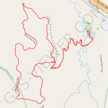
Dogwood Canyon Audubon Center Trail - Cedar Hill, Texas
- Distance: 1.8 mi
- Elevation gain: 82 m
- Maximum elevation: 230 m
- Elevation loss: 83 m
- Minimum elevation: 186 m
- Moving time: 51 m 59 s
- Moving speed: 2.1 mph
- Maximum speed: 3.3 mph
- Total time: 55 m 13 s
- Global speed: 2.0 mph
Interactive trail map
Thank you for supporting this site ❤️
Make a donation
Make a donation
Gear up for your next adventure:
As an Amazon Associate, this site earns from qualifying purchases at no extra cost to you.
Trail profile
- Distance: 1.8 mi
- Elevation gain: 82 m
- Maximum elevation: 230 m
- Elevation loss: 83 m
- Minimum elevation: 186 m
- Moving time: 51 m 59 s
- Moving speed: 2.1 mph
- Maximum speed: 3.3 mph
- Total time: 55 m 13 s
- Global speed: 2.0 mph
Thank you for supporting this site ❤️
Make a donation
Make a donation
Gear up for your next adventure:
As an Amazon Associate, this site earns from qualifying purchases at no extra cost to you.
About this trail
Name: Dogwood Canyon Audubon Center Trail - Cedar Hill, Texas trail, distance, elevation, map, profile, GPS track
Start: Canyon Floor Trail, Cedar Hill, Dallas County, Texas, 75104, United States (32.61338 -96.97099)
End: Canyon Floor Trail, Cedar Hill, Dallas County, Texas, 75104, United States (32.61376 -96.97101)
Coordinates: 32.61020 -96.97537 32.61502 -96.97090
Thank you for supporting this site ❤️
Make a donation
Make a donation
Gear up for your next adventure:
As an Amazon Associate, this site earns from qualifying purchases at no extra cost to you.